
Pictures of MAP in the Night Sky
|
|
|
Pictures of MAP in the Night Sky |
|
|
|
|
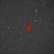
On the left is a picture of MAP (indicated by red arrow). The picture is a 10 second CCD exposure through a 16-inch diameter telescope on the roof of the Brown Physics Department Building, Providence, RI. This picture was taken on July 7, 2001 at 1:30 AM EDT. The approximate Right Ascension and Declination of MAP were 18:25:43 hours and -27.7 degrees; this was during the first of three phasing loop approximately one day before the first Earth perigee. At the time of the photograph, MAP was about 162,000 km away from the Earth. On the right is a STScI Digitized Sky Survey picture of the same region of sky. In a couple of weeks, after two more phasing loops, MAP will swing by the Moon on the way to L2. At L2 MAP will be almost 10 times as far away and 100 times (5 magnitudes) fainter. Movie (animated
GIF) of MAP moving across the night sky
Norm Jarosik used the 36-inch telescope
at the Fitz-Randolph Observatory in Princeton, NJ to also see MAP.
|